Earth System
Science at 20 Oral History Project
Oral History Transcript
Shelby
G. Tilford
Interviewed by Rebecca Wright
Washington, D.C. – June 23, 2009
The
questions in this transcript were asked during an oral history session
conducted at the Earth System Science at 20 Symposium, held at the National
Academy of Sciences, Washington, DC. Dr. Shelby G. Tilford has amended
the answers for clarification purposes; therefore, this transcript does
not exactly match the audio recording.
Wright: Today is June 23, 2009. This oral history is
being conducted with Dr. Shelby Tilford at the National Academy of Sciences
in Washington, D.C. This interview is part of the Earth System Science
at 20 Oral History Project, being conducted to gather experiences from
those who significantly were involved in various efforts of the launch
and evolution of Earth System Science. Interviewer is Rebecca Wright,
assisted by Jennifer Ross-Nazzal. Also present is Dr. Ming-Ying Wei,
NASA Office of Earth Science.
We
thank you for taking a break in the scheduled activities this morning
to be with us. We know that you are considered to be one of the key
founders of the Earth System Science concept. How did you first get
interested in this field?
Tilford:
It was purely by accident. I was always interested in science and originally
started out to be a chemical engineer, I thought, in high school. But
when I got to college, I really didn’t know what I wanted to do,
so I majored in chemistry, math, and physics at Western Kentucky [University,
Bowling Green, Kentucky], and then went on to graduate school at Vanderbilt
[University, Nashville, Tennessee].
Instead
of doing what I expected I would do, pursing a graduate degree in chemical
engineering, I became interested in physical chemistry. That area looked
most attractive at that particular time. There were several physical
chemists at Vanderbilt at that time. The one that I chose for a director,
Dr. K. Keith Innes, had been there a couple of years. He was fairly
young. He was a spectroscopist. I barely knew what spectroscopy was,
but, it sounded interesting to me. The University had just obtained
a brand new high-resolution vacuum ultraviolet spectrograph that he
had been able to support by a grant from NSF [National Science Foundation],
so I thought this would be a great opportunity. He was very interested
in very complex molecules, which are more difficult than atoms, or diatomic
molecules or tri-atomic molecules.
I
wound up doing my PhD thesis on the spectra of dinitrogen substituted
benzene rings. When you substitute two nitrogen atoms in a benzene ring,
you wind up with three different molecules because you can put them
next to each other; you can separate them by one carbon or you separate
them with two carbons. You get three different kinds of spectral signatures
for the three different molecules.
I
spent the first couple of years really learning the ropes. Then my graduate
director came in and told me that he was going on sabbatical at the
end of next year, and I could either finish up my thesis before he left
or wait until he got back. There was not much question of what to do,
so I finished my PhD requirements and thesis in one year.
I
applied for and was awarded a post-doctoral research position at the
[US] Naval Research Laboratory [NRL, Washington DC], where they too,
had just obtained a similar new high-resolution vacuum UV spectrograph.
Very rapidly, of course, I decided that polyatomic molecules were much
more difficult than simpler molecules, so I started working on diatomic
molecules and atoms, which were much more important in understanding
Earth’s atmosphere and the sun. Fortunately, when I went to the
Naval Research Lab they had two of the people who essentially started
space science. One was my boss, Richard [Dick] Tousey, a solar physicist,
who fired the first ultraviolet spectrograph into space on a captured
V-2 German rocket in, I think, 1947 or ’48. His boss was [Herbert]
Herb Friedman, who had done similar experiments, but looking at much
higher energy processes in space. He was an x-ray astronomer. Later
in his career, he was one of the principals in the National Academy
of Science. It was a great start.
We
started working on molecules of atmospheric interest. Also, at the same
time, NRL had an old grazing-incidence spectrograph that could look
at photograph spectra all the way down into the soft x-ray region of
the spectrum. I got involved in looking at the spectra from all kinds
of highly excited atoms. The main reason for this was that in the spectra
that Dick Tousey and his colleagues had taken several years earlier,
(it was the first complete echelle spectra of the ultra-violet energy
output from the sun), there were a lot of unknown spectral lines that
no one understood. We spent a lot of time trying to find out what the
sources were for a lot of these lines. It turned out that molecules
like carbon monoxide and many atomic components were present.
In
the atmosphere, no one had ever photographed a high-resolution detailed
spectrum of molecular nitrogen, carbon monoxide, molecular oxygen (to
some extent) but not completely, and a number of other molecules and
atoms. There are a lot of metals in the sun, so we did some very high-temperature
studies of the absorption spectrum of various metals. We obtained and
analyzed a lot of other spectra, but it was the molecules in the atmosphere
that really interested us. I think we did a pretty good job of categorizing,
cataloging, and identifying most of the lines of atmospheric molecules
in the spectral region above 1000 angstroms.
By
now, I’m in my late 30s, and I’ve been a scientist my entire
career, and if I ever want to do something different, this seemed like
the right time to try it. The solar physics program managers at NASA
wanted a detailee to come down for a year. They didn’t have any
permanent positions, but they needed help in solar physics. They were
just getting ready to select the instruments for the Solar Max [Solar
Maximum Satellite] Mission. I didn’t want to go for an entire
year, so I talked another scientist at NRL into sharing the detaileeship
with me. He went for the first six months, then I arrived at NASA Headquarters
in January of 1976.
During
that six months, the NASA officials talked me into staying in the solar
physics program at NASA, but that was interrupted a few months after
I had agreed to accept the position. That’s when NASA was assigned
the responsibility for trying to understand the ozone issue, and the
Upper Atmospheric Research Program was established. They wanted someone
who knew a little bit about the atmosphere.
Well,
I didn’t know much of anything about how the atmosphere behaved
on a global basis, but I knew quite a bit about what was in it, so they
said, “Why don’t you come over to this new program?”
I did, and it was fascinating.
All
of the controversy at that time was about ozone depletion, and were
CFCs [chlorofluorocarbons] responsible. The reason that NASA ultimately
got the responsibility was because NASA was working on the potential
environmental effects of the Space Shuttle whose exhausts contained
chlorine and depleted ozone. They wanted to understand what the affect
of these missions would be on the atmosphere. How detrimental was it?
Is it a big problem? Is it permanent? Is it this? Is it that?
Before
NASA took the lead in the ozone question, the FAA [Federal Aviation
Administration] was the lead agency [through the Climate Impact Assessment
Program (CIAP)] because there was a similar question about the nitric
oxides in jet engine exhaust. We spent several years studying ozone.
We funded a lot of university researchers, a lot of scientists in NASA,
NOAA [National Oceanic and Atmospheric Administration], and many other
agencies. We had numerous advisory groups and many NASA, national and
international scientific meetings, which eventually culminated in the
banning of CFCs on a global scale. That was really the first time that
any science input had ever made a significant contribution in any global
political decision, so it was fun.
At
this time, within Headquarters, NASA had its Earth Science and observations
programs distributed in various offices within Headquarters. There was
an applications program, which essentially flew new instruments as demonstrations
of new technologies, and for the most part other people performed the
data analysis. Some research in atmospheric, ocean, and solid Earth
Science projects were carried out at Goddard [Space Flight Center],
JPL [Jet Propulsion Laboratory], Langley Research Center, JSC [Johnson
Space Center], Ames Research Center and smaller efforts at each of the
other NASA Centers. Most of these efforts were performed without the
benefit of scientific peer reviews. There was a piece in space science,
which did the upper atmosphere research program. The aircraft program
flew airplanes to make observations, test new instrumentation, and do
calibrations of satellite observations.
In
late 1978 NASA consolidated all of these Earth Science components, except
some dealing with life sciences, into one office. At that time, I accepted
the responsibility for all atmospheric research in total. Additional,
responsibility for the Oceans Program came a couple of years later,
along with the Aircraft Program and Solar-Terrestrial Physics except
the Solar Physics Program I had been involved with earlier. A short
time later, they decided to consolidate the land programs into my area,
so the integrated Earth Science Program just evolved over several years
as the interest of Earth Science increased within NASA.
Wright:
Share with us a little more about that time period when CFCs were banned,
and what that meant, not just on the impact on society, but also on
the impact on the scientific field. As you mentioned, it was the first
time that that had happened.
Tilford:
It was a whole change in attitude, because this was the first time they
had ever banned anything on a global basis, based upon scientific evidence
that it would be damaging to the global environment. It was wonderful.
I think what we did at that time, is that we brought in a lot of external
scientists. We ran a program office, but at the same time we sometimes
tried to provide the scientists a little guidance, regarding the directions
that we and the advisory groups thought were important.
We
had a full-up peer review program. If you wanted to be funded, you had
to write a decent proposal that had to be reviewed by your colleagues,
and it had to be genuine. We took what the National Science Foundation
was doing, and said, “That seems like a good approach.”
We got the scientists involved to a great degree.
The
reports that came out were fairly uniform. There were always a few dissentions.
It’s amazing. The same individuals who lobbied against the fact
that they didn’t think the ozone was being destroyed with CFCs
are the same individuals that testified before Congress that cigarette
smoke doesn’t give you cancer. This includes many of those same
individuals who proclaim that CO2 [carbon dioxide] increase in the atmosphere
has nothing to do with global warming or the monumental melting of arctic
ice. There is a group of scientific lobbyists that are paid by certain
industrial organizations, those who pay people to come up with the “right”
answer.
We
were employed to come up with the right answer, but we didn’t
have any axe to grind, and most of our program managers tried to take
the approach of “give us the facts of your investigation and then
let the scientific community integrate those with other results until
we can reach a consensus.” This approach eventually led to the
Intergovernmental Panel on Climate Change [IPCC] approach to climate
change assessment.
Essentially,
what we tried to do, was give an assessment of the ozone issue. This
involved a lot of scientists. Some of them worked in NASA. Most of them
worked outside of NASA. We came up with approaches using balloons, in
situ measurements, rockets, aircraft, satellites, laboratory measurements,
and continuously improved model simulations. Fortunately, a few years
earlier, NASA had put a solar backscatter ultraviolet instrument on
the Nimbus satellite. After many years, and after many, many iterations
of data analysis, we came up with a pretty good measurement of global
ozone variability.
Then,
the ozone hole came along, and we said, “This is really serious.”
Beginning in the late 1970s, we proposed the Upper Atmospheric Research
Satellite [UARS], which essentially was a set of instruments to measure
many stratospheric components, by several different instrument approaches,
IR [Infra-Red], microwave, backscatter, etc., to measure global stratospheric
winds, to measure and completely analyze all of the aspects of incoming
solar radiation. What impact does it have? Is it constant? Finally,
in 1991 we were able to launch it.
We
supported studies of many of the chemical species, the free radicals,
ozone, OH [Hydroxyl radical, the neutral form of the hydroxide ion (OH–)
and are highly reactive and consequently short-lived], both chlorine
and nitrogen compounds, et cetera, that we thought were important. We
had a fairly large in situ laboratory program, which included not only
studying reaction rate constants, but all kinds of kinetics, temperature
effects on these reactions, and so on. It also involved spectroscopy.
Our laboratory program was about a quarter of the total research program
for the Upper Atmospheric Research Program.
Another
quarter was in modeling. We thought that if you can’t model it,
you don’t understand it, thus you need to study it further or
it doesn’t make much sense to study it. We funded a large number
of modeling groups, both in the university community, in NASA, NOAA,
and numerous other Federal agencies, as well as some industry efforts.
Then the final part was a field measurements program, which included,
as I said before, balloons, aircraft, in situ, etc. Anything that we
could utilize in order to understand if ozone was varying, and if it
is, why.
In
fact, before I left NRL, my colleagues and I tried one experiment when
there was a small program in the Department of Transportation. We designed
what we called a multiple path cell. We were going to titrate in situ
ozone in this multiple path cell, by releasing a small measured amount
of nitric oxide through a complex mechanism, and measure, we thought,
the decomposition rate of ozone in the upper atmosphere. Well, the balloon
started drifting. We lost the control signal; ballast was being released
from the bottom of the gondola and was simultaneously being released
from the top of the balloon, and so on. Therefore, we didn’t get
a lot of information from this experiment. It was an interesting experiment
and experience flying a balloon from Palestine, Texas [National Scientific
Balloon Facility].
I
tried to get involved a little bit with the ozone issue before I came
to NASA. The first thing I did at NASA really was in solar physics.
Dr. Adrienne [F.] Timothy, who was the program manager at that time,
said, “I don’t have time to do the solar constant selection
for the SMM [Solar Maximum Mission] which was to investigate various
aspects of the sun’s variability. We want to put a solar constant
measurement on SMM.” So I carried out that part of the evaluation
and selection process.
I
was involved in the selection of, really, the first solar constant measurement
on a continued basis, which we still have continuous observations after
about six or seven overlapping flights of a solar constant measurement,
but we may not have much longer. We have had continuity. We’ve
gone through, I think, four different principal investigators at four
different institutions in all of these years. It really is a solar issue,
but it’s extremely important to Earth. If we don’t know
whether the sun is varying or not, how are we going to determine if
anything else is varying? And what are the impacts of such variations?
Wright:
Do you recall what year that was that you started that?
Tilford:
1976.
Wright:
Right when you got here.
Tilford:
I started the next week, essentially. Then we completed that selection
before I transferred over to the Upper Atmospheric Research Office.
Wright:
Were you given a lot of room to establish some of the areas that you
wanted, or were you pretty much directed?
Tilford:
In the Upper Atmospheric Research Program, yes. This was a program mandated
by Congress. There was a lot of competition between the Department of
Transportation, the Department of Energy, NOAA, NSF, and NASA. But because
NASA had potentially the biggest impact, through the rockets and the
Shuttle, it was assigned to NASA.
There
was a lot of lobbying for, and against, among the several agencies that
wanted to head the program. At that time, for the first time, NASA was
directed to do a specific program relating to Earth Science. It is part
of the NASA charter that was modified in 1976, [Article 4 of the NASA
Organic Act was passed into law in 1976.]. The Congress actually changed
the NASA charter to include the Upper Atmospheric Research Program and
the Earth.
There
are about three and a half pages [of report language] telling us exactly
what they wanted—not how to do it—but what they wanted.
They wanted to find out, is it? What is it? How bad is it? And what
are corrective procedures? Yes, it was pretty neat.
Actually,
NASA had had another scientist in from JPL [Pasadena, California], Dr.
James King [Jr.], who came in on a temporary basis initially to organize
the program, but they didn’t have a charter at that time. He only
came in for a few months as a detailee. He was going to leave, and Headquarters
detailed Ron Greenwood from Langley [Hampton, Virginia]. Ron didn’t
have a lot of scientific experience, and he talked me into joining the
new Upper Atmosphere Research Program [UARP], which was in the Office
of Space Science. When Ron left in late 1981, I was asked to head up
the UARP program.
With
respect to the Upper Atmosphere, we had complete free reign within scientific
constraints. This was also true as we moved from demonstrating space
techniques into doing research on weather and climate and all of the
other areas of Earth Science. At that time, the ocean program was under
Dr. Stan Wilson, who was one of the other members of the panel today
[NASA Earth System Science at 20: Accomplishments, Plans and Challenges,
National Academy of Sciences, Washington, DC]. He was responsible for
the oceans, and I was responsible for the atmospheres, and so on. Once
Landsat 4 was launched, NASA combined everything into one single Division
with several branches: Atmospheric Dynamics and Radiation Branch, Upper
Atmosphere/Research/Tropsopheric Chemistry Branch, Oceanic Processes
Branch, Flight Programs Branch, Land Processes Branch, Geodynamics Branch,
and Space Plasma Physics Branch.
Later
the Space Plasma Physics Branch was transferred to the Space Science
Program which already included the Solar Physics Program. That program
was moved over to the Earth Science Program and then it moved back to
Space Science. But at the interface, it is difficult to separate the
stratosphere/mesosphere from the ionosphere. They do interact at the
upper levels of the stratosphere/mesosphere, because it’s a diffuse
transition region.
I
actually did a few experiments in airglow observations, interpretation-wise.
When I was at NRL, we fired rockets into the atmosphere and tried to
measure airglow as a function of altitude and determine how much atomic
oxygen was at different altitudes under different conditions and how
much atomic nitrogen was present, and so on. I wasn’t involved
very much in the experimental part of the measurements; I was involved
in the analysis part so I did have a little experience in this area.
Wright:
As the head of these programs, were you able to do what you had grown
to love through these years, or were you having to do more of the program
side?
Tilford:
Very quickly it got all almost completely into the program side. I mean,
we made science decisions and programmatic decisions at the program
level. As far as hands-on, no, I didn’t do anything, but I wasn’t
too unhappy about that. I was enjoying what I was doing.
Finally,
things were rearranged again, and again, and again, in terms of NASA’s
organization. In 1992 the Earth Science Division was made into a separate
office, the Office of Mission to Planet Earth, and then after I retired,
it was recombined with Space Science into a single office again. I think
they have to do it every few years or they’re not happy, but that’s
my personal opinion.
Anyway,
how we really got involved in this program big-time, I think, were discussions
with John McElroy, a former NASA employee, who had gone over to head
up NOAA’s NESDIS [National Environmental Satellite, Data, and
Information Service] program. NOAA was discussing at that time what
they were going to do for the next generation of geostationary satellites.
Originally, NASA pioneered in the Office of Applications the geostationary
observations, and Professor Verner E. Suomi from University of Wisconsin,
granddaddy of geostationary observations, had designed this sensor (camera)
to put in geostationary orbit. There were a couple of talks that mentioned
it in the last few days. He was quite a talented and unique individual
who made so many contributions for the advancement of Earth Science,
from the observational, data processing and storage, and interpretational
areas.
Anyway,
they were now in the stage at NOAA where they were going to the next
generation geostationary observatory. John wanted to do something better.
Originally NOAA had a rotating camera, which actually was a fixed camera
on a rotating satellite 22,500 miles above the Earth, which during every
revolution, looked at a slightly different position on the Earth (so
that it covered a north to south area every 30 minutes). He wanted to
set up a geostationary fixed satellite camera pointing toward the Earth.
It was going to be big and complex. He and I talked a lot, and I felt
we needed a more robust satellite program for Earth Science to do a
lot more things.
At
this time NASA appointed a new Associate Administrator, an energetic
individual, Dr. Burt [Burton I.] Edelson, who was really a communication
expert, but had had very little knowledge about Earth Science. But he
was enthused about Earth Science and the potential of satellites to
improve our understanding of how the Earth System works. He was a close
friend of Jim [James M.] Beggs, who was currently the Administrator
of NASA. Dr. Hans Mark, a former director of [NASA] Ames [Research Center,
Moffett Field, California], was his deputy. At this time, the Space
Shuttle was a big question as to whether it would ever fly or not, and
especially how it would fly and where it would fly, when it would fly,
and so on. They were having trouble keeping it sold because it was such
a big program.
This
was in 1981 and ’82 when all of this took place. I had been at
the agency now for five years. We had flown, or were soon to fly a number
of instruments, several satellites, and had several things, including
an ocean altimeter, SAGE [Stratospheric Aerosol and Gas Experiment]
and UARS, the Upper Atmospheric Research Satellite, was planned to be
launched. But we thought we should do more. So between myself and Dr.
Dixon [M.] Butler and a few other people and Burt, we went up and talked
to Jim Beggs about this new Earth Science initiative, which we couldn’t
sell under any circumstances. NASA had previously not been very interested
in anything except technology demonstrations, as far as Earth Science.
After the Upper Atmospheric Research Program, there was a little more
interest.
This
was the same year that they were going to do UNISPACE ’82 [United
Nations Conference on the Exploration and Peaceful Uses of Outer Space].
This was a big deal for space. All of the space agencies and all of
the people related to that from every country in the world that had
a space program were going to meet in Vienna [Austria] in the middle
of 1982. Beggs reply was, “I don’t know. We have the Shuttle
issue.”
At
this time NASA was still wanting to fly the Shuttle in polar orbits.
So John and I got together and discussed it in a little detail, and
he said, “Now, we could even launch our polar orbiting satellites
from the Shuttle, and we could make them serviceable so that we don’t
have to replace a satellite. We just replace the instrument.”
Much like what eventually has happened with the Hubble Space Telescope,
but this was going to be in polar orbit.
I
said, “Well, we could complement that with an integrated Earth
Science Program, which would demonstrate new instruments for NOAA, and
maybe replace Landsat [Land Remote Sensing Satellite], and do a few
other things. If they’re going to be serviceable, this will be
a very economic approach.”
But
this was all wrong—well, we were figuring out how to do this.
We could sell a program. He [Beggs] could benefit. It would all be nice.
We discussed this, and he backed it, and I backed it as Dixon and Burt
had done for some time.
Meantime,
all of the Space Science people didn’t want any part of the Shuttle
because if they were going to put a telescope on the Shuttle and men
are moving around, they’re not going to be able to point the thing
precisely and hold it. They had all of these arguments. Professor Tom
[M.] Donahue, who was Chairman of the Space Science Board of the National
Research Council of the National Academy of Sciences, opposed it very
much. Of course, all of the astronomers didn’t like it. Earth
Science liked it.
But
at the time, we didn’t know yet that just because of mass and
propulsion capability, that you would never be able to put the Shuttle
in a polar orbit and service something, because there was no weight
left. It’s a whole lot harder to put spacecraft in a polar orbit
than it is in a lower Earth orbit, because of all that momentum change
you have to do, whereas, you can use the Earth’s rotation to help
you, when you fly in a low latitude orbit. And if you’re going
into polar orbit, it takes a much bigger rocket to get the same payload
into orbit. The reusable Shuttle makes this problem much worse
Burt
went up and talked to his old roommate from the Naval Academy. It turns
out that Jim Beggs and Burt Edelson roomed together when they were at
the [US] Naval Academy, so Burt went and talked to Jim. At that time,
the Shuttle flying in polar orbit was still a good argument, so the
Shuttle was going to fly in polar orbit. Beggs said, “Well, let’s
go do this. This is a good thing to do.”
We
got a group together and had a couple of meetings. We had about twenty
scientists of various kinds: atmospheric, oceanographic, land people,
and so on. Professor Richard Goody, who was at Harvard [University,
Cambridge, Massachusetts], was involved because he had a lot of prestige
with the astrophysics community and Burt thought much of him. Then Beggs
talked the author of Space, James Michener, into going with us.
We
all went to Vienna, and Michener and Goody presented our program, with
all its benefits of a better understanding of the Earth System to the
international community. We were shot down! It was really not very exciting.
No one accepted it. They would not buy into it. They thought it was
the United States trying to take over the world, and that we were going
to keep all of the data, and we were going to have all of the information
on their countries, and they didn’t want that. Sounds a lot like
India, or China, or North Korea today, but that was the attitude.
We
sort of came home with our tails tucked between our legs. We said, “This
isn’t going to work.” Beggs said, “Well, I’d
still like to do it.” So we all got together and agreed that we
would set up this huge group of scientists from every aspect of Earth
Science, get them together, and put together a plan for what this could
and would do.
Now,
at this time, it was also a real problem between the different disciplines
in Earth Science—Dr. Ming-Ying [Wei] will tell you it still exists
to a great degree, but not to the extent that existed in 1982 —that
is oceanographers would barely talk to atmospheric scientists, and neither
one of them talk to land scientists. In addition there was the geodynamics/solid
Earth community which looked at things on a completely different time
scale. There was simply very little interdisciplinary communications.
It was three, or four, different, separate areas completely.
We
then contacted Dr. Francis [P.] Bretherton, asked him if he would chair
this new Earth Science Committee. We told him it would take about a
year probably to get it completed. He was at that time, I think, head
of NCAR [National Center for Atmospheric Research], and he had been
closely associated with UCAR [University Corporation for Atmospheric
Research]. His training was in applied mathematics, and he had published
significant papers in both oceans related and atmospheric related topics,
so we thought he was the right kind of individual to do this. Again,
now we brought in a larger group. After thinking about it for a while,
he agreed that it would be a difficult job, but he thought it would
be a very worthwhile thing to do.
We
also brought in people from all of the other agencies that would attend.
NOAA, National Science Foundation, Department of Energy, FAA, USGS [United
States Geological Survey], USDA [United States Department of Agriculture],
all of the agencies that we thought might help us or complain about
us. Then we set out to put together a science rationale for doing Mission
to Planet Earth. We didn’t have a name for it. At that time it
was the Earth Science Program. With Francis working with NASA, the science
community, the National Academy of Sciences, we finally put together
a very impressive group of scientists and Agency representatives and
began the process. [Complete list of participants.]
Francis,
the Committee, assisted by Ray Arnold, Dixon Butler, Stan Wilson, Bob
Watson, me, and other members of our Division, along with various representatives
from the Centers, worked and we worked and we worked. We formulated
the Committee in 1982.
The
first meeting was early in 1983. What we figured to be a one-year task
wasn’t. We didn’t finish in 1983. We didn’t finish
in 1984. We had still not finished in 1985. But we said, we’ve
got to get a report out.
At
that time, 1986 the Bretherton Committee [Earth System Science Committee
of the NASA Advisory Council] came out with an interim report; it was
an overview of the Earth System Science Program. It was called, “A
Program for Global Change: Earth System Science Program.” It’s
a beautiful brochure, and it’s got a lot of information in it.
It tells what needs to be done, but we still had some real problems.
Now, the whole thing was put together in what is now called The
Bretherton Chart.
It
couples everything, almost every element of the Earth system, going
from the sun to the center of the Earth. That includes the solar input,
the effect of the upper atmosphere, lower atmosphere, the troposphere,
et cetera. It covers weather, it covers oceans, it covers land, it covers
the solid Earth. We tried to put together something that would integrate
the Earth as an integrated science program. That’s what the chart
does.
But
we still weren’t finished, because we still had a lot of dissension
between oceanographers and atmospheric scientists and solid Earth scientists
in terms of priorities. Everybody wanted to be first. Well, we didn’t
want everybody to be first. We wanted everybody to work together. This
was hard.
So
three years later, this came out [referring to document] that was called
an overview. It was called, “A Closer View.” This was primarily
Francis Bretherton with lots of help from a number of individuals. Let’s
see, who else were the big players? We had many of them. I think all
of the people are listed here. Let’s see. There was oceanographer
Dr. Jim [D. James] Baker, Joint Oceanographic Institutions, Inc.; meteorologist
Professor John [A.] Dutton, Pennsylvania State University; biogeochemical
cycles Professor Berrien Moore (III), University of New Hampshire; solid
Earth scientist Dr. Kevin [C.] Burke, NASA Lunar and Planetary Institute;
and remote sensing and atmospheric scientist Dr. Moustafa Chahine, Jet
Propulsion Laboratory.
And
we had expert people like Professor Jim [James J.] McCarthy, biologist;
Professor Ron [Ronald G.] Prinn, a modeler; Dr. Willy [Wilford W.] Weeks,
ice; Professor Paul [J.] Zinke, trees and living things; Professor [Lennard
A.] Len Fisk, space plasma physicist; Professor [Daniel B.] Botkin,
a medical doctor who got interested in ecology research, and Professor
David A. Langrebe, land remote sensing. We had a whole group of other
people from various NASA centers, numerous members of my NASA Headquarters
staff and several support institutions and they all worked together.
We spent many, many meetings and many, many hours together. Finally,
this other draft came out. It’s a much more complex, integrated
chart than the one that I showed you.
All
of this came together in 1988-89. This was a formulation by this group
of scientists and about five or six [NASA] Headquarters people, including
four of whom you saw at the table the other day—Dixon Butler,
Stan Wilson, Bill Townsend, and myself. Dixon played a huge role in
the EOS [Earth Observing System] program, before it became EOS, and
with developing the data system after it became EOS. There are also
people like Dr. Bob [Robert T.] Watson who had been extremely involved
in the ozone issue and went on to chair many of the international assessment
programs.
We
were intimately involved at this time, too, with their International
Programs Office, because, as part of this, we agreed very early on that
we could not again do it alone in the United States. We had to engage
the people that disagreed with us in Vienna. We set out to fly other
countries’ instruments, joint instruments, fly our instruments
on their satellites, or their rockets or whatever. This took a tremendous
amount of time. First, we had to deal with the different disciplines,
because they all didn’t agree or didn’t think the other
science was that important. Then, at home, we had to get together.
Fortunately,
we had a great group of people in Washington at that time. We had representatives
from NOAA. First it was John [H.] McElroy, and then after that it was
William [P.] Bishop, [J. Michael] Mike Hall, and [Russell] Russ Koffler.
We had the National Science Foundation. First was the director of geosciences,
William [J.] Merrell, Jr. and he left shortly thereafter. At that time,
[Robert W.] Bob Corell came in, and he was extremely involved, as was
Nancy Ann Brewster Budden. We had Dr. Ari Patrinos of the Department
of Energy involved. We had representatives of the FAA and USGS. The
main thing, we also had OSTP [Office of Science & Technology Policy]
in the person of Richard G. Johnson and the Office of Management and
Budget [OMB], in the person of Dr. Jack [D.] Fellows who were a tremendous
help at all stages of this process. We had some Congressional staffers
there. We set up this integrated approach which included many international
participants.
Let’s
talk about international for a minute. We had had discussions with the
English, and they actually had an instrument on UARS, a radiometer to
measure certain minor species with a state-of-the-art instrument called
a pressure modulated radiometer. I won’t go into technical details,
but it was unique. And, it had worked in the laboratory, and we thought
we could adapt it to work in space. They funded it, which was wonderful.
We
had talked with the French, and we had talked with the Germans. We had
already agreed to fly some Germany provided Earth Science instruments
on the Shuttle. Then we talked to the French, who had agreed to jointly
fund TOPEX/Poseidon [Ocean Topography Experiment]. In fact, we built
the instrument, and they launched it on their satellite, but with some
of their software. We talked to a number of scientists, which we signed
up as part of the science team, in other countries. We have also had
a very good working relationship with Japan in so many ways. Japan provided
the ADEOS [Advanced Earth Observing Satellite] spacecraft for the US
NSCAT scatterometer and the joint Japan/US TRMM [Tropical Rainfall Measuring
Mission] mission has been a fantastic success.
In
addition, we got to one point in the early 1990s where, if you remember
after the Shuttle [Challenger, STS 51-L, 1986] blew up, we were sort
of hurting for any way to launch a satellite. Our SBUVs [Solar Backscatter
Ultraviolet Spectrometers] were about to fail, and we were going to
lose a continuous trend in the ozone data set, which at that time, we
needed to prove that the ozone hole is real. However, we couldn’t
fly it. We simply had no way in the US to fly it.
One
of the Russians, who had been at one of our meetings said, “Maybe
you could fly it on one of our rockets.” They had a satellite,
and they had some space on it. We said, “That’s a good idea.”
So these negotiations were extremely interesting.
I
visited Russia about five times, and they visited over here five or
six times. We finally got all of the details worked out. But the [US]
State Department wouldn’t let us turn this instrument over to
the Russians; it had to be in our possession at all times. Well, none
of us wanted to spend that much time in Russia, because it was going
to have to be there for two or three months before they could integrate
it onto their satellite. We wound up having this instrument stored in
the living room of the science attaché in Moscow.
Finally,
we did launch it. The Russians have a unique launch vehicle system.
They roll this door up—this is all in one day—they roll
the rocket out, they attach the satellite to it, they lift it up, and
they fire it in a few hours. I wasn’t there for the launch, but
we had a delegation of about 26 people in Russia that day. It turned
out that on the afternoon of the day of the launch is when they overthrew
[President of the Soviet Union Mikhail] Gorbachev. We had 26 people
in Russia, and we couldn’t communicate with them. It was sort
of a mess. But shortly thereafter is when [Boris] Yeltsin got up on
the tank, made a fantastic speech, and everything settled down. Communism
was just about gone at this time, but we had a lot of guys there watching.
They all got home safely.
Wright:
And you had a satellite up.
Tilford:
We had a satellite up. It was working. So it was a little bit different,
but it was good. It filled a data gap that could have been interrupted.
But still, we had our problems in launching UARS because after the Shuttle
blew up, we had on this satellite a solid hydrogen tank, because one
of our instruments had to be cooled down to essentially liquid helium
temperature. The most energy-efficient way of cooling this instrument
was with solid hydrogen, because up there it’s cold. We could
put it in a double tank in a big vacuum bottle. We were going to launch
that on the Shuttle. Well, no way after the accident was NASA going
to put a piece of solid hydrogen on the Shuttle. We had a delay in launching
UARS until we could replace the solid hydrogen tank, with a large liquid
He tank. UARS was launched on the Shuttle in September 1991.
This
is a side story, but it’s interesting. It makes you wonder. We
were having the tenth anniversary of the launch of UARS at Goddard [Space
Flight Center, Greenbelt, Maryland] in September of 2001. About 10:15
am one of the astronauts who launched UARS from the Shuttle ten years
earlier was describing the launch with viewgraphs and a movie. At 10:30
am that morning [September 11, 2001], the screen went blank, and they
showed this plane hitting the [World Trade Center] in New York. There
was no commentary just the video. They didn’t tell us anything.
They just showed this on the screen. So UARS had an interesting but
harrowing tenth anniversary celebration. Everybody left and went home,
and a few people drove to California because you couldn’t get
on an airplane. I’ve never seen such chaos in Washington [DC]
in my life. That was a bad day. Just a sideline.
On
the international scene, we really had good participation by a number
of foreign countries. I think that has continued until today with Canada,
England, France, Germany, Japan and with a lot of minor countries. We
even tried to help out Brazil and Uruguay and countries like that by
signing joint data agreements.
Another
thing that we did as we were developing the Earth Science Program is
make a significant change. For most of NASA’s history, the data
that is obtained from any particular instrument, essentially all priorities
and rights were given to the Principal Investigator [PI] and his team.
Well, all of us, I think, or most of us, except for the PIs, felt that
that’s not the way it should be. We figured if this was Earth
Science, and we were spending all this taxpayers’ money on this
program, that we had to change the data policy of NASA with respect
to Earth Science.
So
from day one when we let out the announcement of opportunity for the
first mission—well, integrated missions, at that time; we wanted
to see what kinds of instruments we received, how we could put them
together in an integrated, efficient fashion so that it made sense.
Some of them took longer to develop at times than others. But anyway,
essentially from day one, we said we’ve got to change the data
policy. The PI is responsible for developing the algorithm. However,
if there is someone else with a competing idea to develop an algorithm,
he has access to the primary data, also. This was quite a shock to all
of the PIs in Earth Science.
Wright:
That was truly a monumental change of direction.
Tilford:
Yes, but it worked. Eventually. Not completely. But it did work. I think
it was a good thing for many, many reasons. Especially the one to get
the most information out of any data that might be obtained.
Wright:
Did this help sell the entire concept to the international partners?
Tilford:
Yes. This made a big impression on them. We required a similar thing
from everyone who signed up to use it, that they would have to turn—not
instantaneously—but that they would turn their data over to a
data pool which would be assessable to the general public.
This
part of EOS—the Earth Observing Data System—was of a scope
no one had ever attempted to put together , not this kind of complicated
data system in the non-classified world. This was a big thing, because
it was going to run the satellites, it was going to get the data down,
it was going to use the algorithms that the PIs developed to put these
things in distributive data centers. We had data facilities strung all
over NASA and USGS and a few other places. These data centers were going
to communicate with each other, and they were going to run the algorithms.
They were going to do all of these functions, and then they were going
to archive the data. This is a lot of data. This is more data than you
can think about. I don’t even know how many petabytes we’re
talking about.
At
that time, no one had a system that would even come close to making
all of this work the way we thought we wanted. But we tried. After we
got through the initial process, I gave Dixon Butler the job of being
the EOS data czar. He brought a lot of data people in, a lot of industry
people in, a lot of other people in. We had to start on this before
we could start the program, essentially. We wouldn’t have time
to do it after everything else got built, so we had to do them in parallel.
This was, of course, because of budget limitations and because of the
recent NASA Administrators, it was reduced, and it was reduced, and
it was reduced.
It’s
still a unique system. I think it’s probably one of the best data
systems in the world. It has its faults, because we changed, or had
to change, it several times in midstream, because what we started wasn’t
capable of being completed at that time. We didn’t know that in
the beginning. We took the manufacturers’ word for it, but it
has changed hands two or three times. I think without a doubt it is
still the most comprehensive data system that exists for non-classified
data.
I
hope they use it for the new Climate Data Center where all of this information
should go into one place that has accessibility to most all Earth Science
data that is available. It has to. I don’t think it has to go
in one physical place, but it has to go some place where anyone who
needs climate data can get it. Right now, NOAA has a facility in Asheville,
North Carolina, that’s called the National Climatic Data Center
[NCDC]. They’ve been given responsibility to set up a climate
data system, as well as a weather data system. Dr. Tom [Thomas R.] Karl,
who was director of that facility, is now, I think, acting czar for
the new initiative on data. I’m going to try to persuade NASA
and USGS to sign up without difficulty and to be an integrated part
of this approach, because it makes so much sense from my point of view,
at least, which doesn’t carry much weight anymore. I think that
would be a wonderful thing to do, first on a national basis, but ultimately
on an international basis.
Let’s
talk about interagency cooperation. Cooperation between the agencies,
because of the people involved, was actually much easier than I had
anticipated based on previous experiences. I believe that happened because
there were some new people involved. We had very good participation
with the other agencies, having the cooperation of the Office of Management
and Budget, and essentially, the Chief Scientist for the United States,
the OSTP at that time, Office of Science and Technology Policy. We had
his support, and the people that worked for him, we had their support.
They were active participants.
This
approach evolved from essentially 1982 when we started talking about
an integrated Earth Science Program. Originally, there was a tremendous
fight over who was going to be in charge of this committee that we were
putting together with participants from all of these agencies. Because
of our previous experience with all of these, “who’s in
charge issues,” we, NASA, said, “We really don’t want
to be in charge,” because we’d been in charge once and blew
it. NASA was going to put in most of the money, or request most of the
money from Congress, but we felt if we were in charge of the committee,
or chaired the committee even, that it would be difficult not seeing
that NASA was going to take all of the money and other agencies would
get upset.
So
we first agreed that Tony [Anthony J.] Calio, who had been an associate
administrator [Office of Applications] at NASA, who I worked under for
several years but now the director of NOAA, we agreed that Tony Calio
would be a good person with interagency experience for this position,
at the first meeting of the CES, the Committee on Earth Sciences, I
think it was called. I forget all of these acronyms. There’s been
so many of them in the past, but all agencies had agreed he’d
be in charge.
Well,
the first meeting we had with all of these people at the agency level—at
that time, Dale [D.] Myers, the Deputy Administrator of NASA, was our
representative, at Beggs’s selection. Tony wanted to take over
the whole program and let NOAA do it. Well, NOAA doesn’t have
much engineering experience. They don’t do too well in data. There
are a few minor things that were missing. No one thought that NOAA,
an operational agency, although they have done a good job in weather,
a little bit poorer job in oceans, was capable of being in charge of
an integrated, agency wide, research program. Nevertheless, many of
the participants thought NOAA does a good job in its operational function.
They do have to be integral to anything that’s done in Earth observations,
analysis, and prediction, as does USGS.
After
this first meeting, there was a terrible eruption. I think we held the
meeting in the Executive Office Building adjacent to the White House.
Everybody just blew up. The next two weeks, OSTP removed Tony as the
head of the Committee on Earth Sciences (CES) and Dr. Dallas [L.] Peck
of USGS was appointed to be the new chairman of CES. Dallas was a good
selection; he worked out fine, and got along well with almost all of
the participating agencies. After that, we had sub-groups that met frequently;
however, the CES committee met only periodically.
The
little small committee met every week. At least once, maybe twice. It
included all of the principal agencies. Dr. Jack Fellows at that time
was the OMB examiner. He was there. NSF and all of the other subgroup
participants met and worked issues out together. It all worked out well.
Everybody was in step.
As
we got a little bit further along, and someone, I don’t remember
whether it was OMB or OSTP, decided that what we really needed was an
integrated budget across all of the agencies where we would define our
programs as Earth System Science programs or climate programs, anything
that fit in this particular realm. This would eventually be a budget
that was outside of the individual agencies, so that the heads of the
agencies couldn’t veto it. Well, oh boy! We did this. The first
year, everybody is scared to death to put their programs in as an integral
part of this new Earth System Science, Global Climate (it’s had
numerous names over the years) program crosscut budget settling eventually
as the U.S. Global Change Research Program..
But
we did a cross-cut budget the first year. NASA didn’t even put
EOS in it that year, because the agency, with good reason, thought that
if we did, it would just get cut out completely. So, everybody played
it cautiously until the next year. It worked fine the first year, but
still not a separate budget. We’re not independent of the agency
head making decisions on it. Second year, everybody got in step with
the program. I think we published, and they may still do, an Integrated
Earth Science Program crosscut budget. At this time, it may be the Climate
Program. But every year, we put together a little booklet that we forwarded
to OMB, which OMB forwards on to the Congress. It was an integrated
budget for Earth Science.
It
worked fine for about two or three years, until they started trying
to isolate this as an integrated budget. That blew up after a while.
Everybody got mad. This was not the way to proceed. NASA was not too
uncomfortable with it at first, but that changed with people. The Department
of Agriculture said, “No way is that going to happen. The head
of the Department of Agriculture is going to make a final decision on
any budget that USGS has.” The Department of Commerce said the
same thing about NOAA. So on, and so on, and so on. Well, that disappeared.
So
it was a great idea. It’s still a great idea. There have been
a number of papers written by people like Charlie [Charles F.] Kennel,
who took over after I left NASA, and by Jack Fellows, and a number of
other people, who would propose that all of the Earth Science agencies
except NASA be integrated into a single climate area and would have
its own separate budget. It would be a line item budget, so that it
would be visible and understandable.
Now,
I would personally lobby for NASA to be part of that, with one exception,
and it’s a big exception—that is, the technology required
to put instruments in space. There is no other agency, with the exception
of DoD [Department of Defense], and you certainly can’t have it
there. The Department of Energy has actually done some space work, but
there’s no agency that could really provide, I think, the engineering
technology besides NASA. So I would exclude NASA from that, but would
include them as an integral part of the program.
NASA’s
space technology is unique. I don’t think anyone disagrees with
that. I don’t think you can separate the technology because of
the integrated way it works. You can’t take out technology for
Earth science, because you have the launch and propulsion capabilities,
you have the integrations capabilities, you have the tracking capability.
That makes it more complicated.
But
anyway, they have made these proposals, which I think would be a good
idea for climate-related processes and understanding Earth and to do
the required modeling that is going to be associated with trying to
do real assessments of how serious the climate problem is, how serious
the CO2 problem is, what’s the impact on future energy uses, and
everything associated with these questions.
Dixon
was a jewel. He really did jump in and overdo things, but you got to.
Dixon and I worked very closely together. The fun part really was that
Dixon and I and a fellow named [D.] Brent Smith, who used to be at NASA—he’s
now at NOAA, and he was in the International Affairs Office—we
used to travel together. A lot. In Europe and every place else. The
funniest thing was that I would go in and have a beer or something,
but Dixon is a Christian Scientist, so he didn’t drink. Brent
Smith is extremely religious so he didn’t drink. So here are these
two non-drinkers who I’m always sitting in a bar with. I felt
bad about it, but it was also fun.
Wei:
They always would leave a large tip!
Tilford:
Yes. They would have water and/or a soda.
Wright:
You mentioned you had this very large group of scientists that you got
together. If you can, share with us some of the initial reaction from
some of these people when you first invited them to be part of this
group for discussion. Were they ready for this type of movement?
Tilford:
A lot of them were really ready for it. Several of them had known about
the ozone issue and how that was done. We sort of used that concept
for going on into a bigger Earth Science approach. I think most of them
were pleased.
The
university people, I think, perceived this to be an opportunity to get
more graduate students in the program. In fact, that was one of our
objectives, to get more students involved through grants, so that the
next generation would be better than this one. I think most of the university
people wanted to participate, but a lot of them were a little bit afraid
that their discipline would be left out, so they wanted to make sure
that they got a word in. They had a motive, whereas the agencies didn’t.
So in a sense, we got the support of the scientists. It was easier to
get them to participate than it was to getting really active participation
from some of the other agencies.
But
the other agencies, for the most part, really had an interest in what
we were going to do, because it would affect them. NSF has a fairly
big atmospheric program, in a sense. From a ground-based point of view,
from an aircraft point of view, they did a lot. They did a lot of modeling.
In fact, in many areas, they did, at that time, more modeling than NASA
did. So they were willing to participate. The head of that office shortly
after the program was conceived was Bob Corell, who was as enthusiastic
as I was about this program. He was really helpful. The fact that he
was an oceanographer—I’ve always been thought of as an atmospheric
scientist, but that’s not what I am, but that’s what all
of the oceanographers think. That helped, having an oceanographer working
with or against this atmospheric scientist, balanced it off a little
bit.
The
biggest problem was with Solid Earth people, because NASA had been carrying
out for a number of years an experiment called LAGEOS [Laser Geodynamic
Satellite], which measured the gravity field of the Earth, and it’s
still continuing today. What this is, is NASA made these great big golf
balls, real heavy, and put little tiny mirrors, about this big [gestures
to indicate size], all around it. Then they launched it into an orbit
that circles around Earth at a very high altitude. What they did then
is they would shoot lasers at this ball, and it would reflect down.
As the Earth rotated around from several different places, they would
shoot these lasers at it, and precisely, within about a few millimeters,
they could see the difference in the gravity pull, as the Earth rotated
and the satellites circulated.
That’s
how we know so much about the gravity field and how it changes, because
anything you fly, unless you fly it at a very high altitude, is going
to have a big gravity pull. Newton’s Theory [of Universal Gravitation].
It’s going to pull the two objects together, so they were a little
bit concerned that maybe it wouldn’t include Solid Earth.
The
timescales, too, were a real big problem, because we were talking about
timescales in terms of the ozone, in terms of weeks to days to years,
because the rate at which ozone depletion was taking place at that time.
Most of the phenomenon we’re talking about in terms of weather
was within days. All of our models in weather, for the most part, are
good for days.
Now,
when you get to the ocean, at this time, we didn’t have a lot
of information on the ocean in the early 1970s. There had been a few
measurements in terms of very large-scale altimeters and such, but there
was no small area, a few kilometers measurements. You did it by ships,
but you didn’t know how high the ship was. The first time we ever
understood what the height of the ocean variability was, was after we
flew an altimeter on TOPEX/Poseidon, to any precision whatsoever. Now,
that’s the session that I just went to listen to, the results
of some of those measurements and what we have learned. We can now measure
to within one and a half centimeters, anyplace that this satellite flies,
which is marvelous, from my point of view.
But
there are things that do make a difference here. With some of the laser
altimeters and the synthetic aperture radars, we can measure major earthquakes
within a centimeter. There are a number of faults in California, especially
after some of the Alaska earthquakes, where all you need is a yardstick,
or I should say a ruler, because most of them are not more than a foot,
but those are big displacements. Well now, when flying some of the altimeters,
we can detect movements that we could never see before. In terms of
those kinds of things, the plate tectonics, they’re fascinating
and interesting, but they move at the same rate your fingernail grows
about an eighth of an inch a month, or something like that. Now we can
do those things from space. Many of these we could not do before. A
lot of things just happened, without being noticed while the event is
in progress, now we can obtain extra information from them.
The
Solid Earth people, especially those interested in plate tectonics,
were really concerned that they would be left out. It’s harder
to integrate what’s happening there. Most of those are episodic,
in the sense that they happen big and infrequently, like a volcano,
that messes up everything. Atmosphere, ocean, everything changes because
of it. Heat budget changes so rapidly because aerosols absorb so much
sunlight that the whole heating system and cooling system of Earth is
changed. So you need to know as much information as possible about extent,
concentration, attenuation, etc. to evaluate the probable perturbations
that may occur, and how the surface of Earth will be affected.
Fortunately,
for a couple of those large volcanic eruptions over the past two decades
we had aerosol monitors flying on satellites. They measured both aerosols
and clouds, but with a big earthquake aerosols dominate, and they really
change the climate significantly, probably the biggest impacts that
we’ve ever been able to see results of, except for results of
super volcanoes like the one we have in Yellowstone [National Park,
Wyoming], which is scary. If you remember a couple of years ago, the
lake tilted a little bit. The lake water started running out of the
wrong end of the lake. Everybody thought, and I did too, that this might
be the precursor of another super volcano, because the last time that
happened was several thousand years ago and it dumped several inches
of ash on Kansas. That’s pretty far away.
Another
geologist predicts that magma would be flung fifty kilometers into the
atmosphere. Within a thousand kilometers virtually all life would be
killed by falling ash, lava flows, and the sheer explosive force of
the eruption. One thousand cubic kilometers of lava would pour out of
the volcano, enough to coat the whole USA with a layer five inches thick.
But the problem is, with something like that, the Earth is going to
cool off right quick, because the sunlight can’t get through the
atmosphere and the whole dynamics change. There’s nothing we can
do except watch, at that point.
Anyway,
we included some of that. Everybody eventually was happy, I think. Almost
everyone was happy with the Bretherton Report when it was finally published.
A lot of people accepted it as a road map for things to follow.
Wright:
The report has Francis Bretherton’s name, but how much were you
intimately involved in putting that together?
Tilford:
I sort of helped it along a little bit here and there. I tried to guide
them without guiding them. I found, if you’re very active and
pushy, you don’t get much done. But if you can help them a little
bit here and there, it’s a lot easier to do. That’s the
way I worked the whole program, because if you get too much involved,
it becomes yours instead of his, or theirs, and I didn’t want
that. It was his report, and the committee’s report. It wasn’t
my report.
But,
yes, I played a supporting role. I was at nearly every meeting, and
I was right in the middle of discussions. We’d talk about pros
and cons of various proposal and suggestions, and I’d of course
give my opinion. I tried not to dominate it, because I have learned
that doesn’t work.
Wright:
Sounds like a good lesson learned.
Tilford:
Yes. We tried to play the same role in the interagency thing, because
we had learned if we tried to do it, we just would lose. We wanted the
other agencies to accept it. As Peter [W.] Backlund, one of the super
staff individuals that used to work for me, said, “What I think
you realized is that if you can make it a national program, rather than
an agency program, you’d have a whole lot better chance of getting
it to work.” Which is true. Once something becomes a national
priority or has a national visibility, the probability that it can be
sold and implemented is much greater. I didn’t fully realize that
at the time, but that’s the way it is. If you can make it where
it really doesn’t belong to one agency, but it belongs to the
United States, then yes, that’s a lot easier to get across—not
only to the public, but to the Congress and everybody else. That’s
essentially the role that NASA tried to play, with some exceptions.
That’s
why we had other people in charge of components of the program. For
the working group, Bob Corell of NSF chaired the group, and then there
was Dallas Peck from USGS for the big CES committee. We had the dominant
budget, and probably we had 80 or 90 percent of what was going into
Earth Science. That’s the reason we didn’t want to say that
it was a NASA program, because we would never have been able to get
it approved.
Wright:
You mentioned earlier about it then growing into the next step, which
would be an international or a global endeavor.
Tilford:
Well, we did all this in parallel. We slowly worked it up, so we would
cooperate with this organization, or that country, or that agency and
so on. That’s still going on. The Japanese have been wonderful
partners in this whole thing. We fly together, we exchange data. The
same way with France. The same with England, although they don’t
have the launch capability. We’ve tried to work with country after
country after country in a cooperative manner. We fly their experiments
on our satellites. Germany, they’ve built numerous instruments,
a few to fly on our satellites, but mostly to fly on the Shuttle. They
were very interested in utilizing the Shuttle and having a man fly in
space, which Japan and France were too. That was initially part of the
trade-offs, that they would get an astronaut, if they would cooperate
in other aspects of the space program.
Wright:
So it expanded into the human space flight as well.
Tilford:
Exactly. We did fly a number of instruments on the Shuttle, as I mentioned.
We flew an infrared interferometer, which measured at extremely high
resolution the spectra of the sun on two different occasions. One when
it was a little bit active, one when it was pretty quiet, because that
gave us the highest resolution spectrum we had ever had of the sun over
the whole infrared wavelength region. That atlas is about this thick
[gestures to indicate size], with all of the observed solar lines in
it. If anyone ever needs to utilize the solar spectrum for something,
they’ll know where lines are, what intensity, how they fluctuate,
and so on.
So
you don’t need to fly that all of the time. You need to know what
it is. What you need to know is how much the sun is varying, because
a one percent change in the output of the sun is going to make a big
impact on climate and us. Up or down.
Wright:
You have talked off and on about the DoD. Did you know what their thoughts
were on this initiative to bring all of these agencies and disciplines
together, as well as international?
Tilford:
They didn’t interfere with us too much about that. What we were
concerned with didn’t require looking at the ground at a certain
resolution point in a time frame, because that potentially had defense
implications. So it got better and better, and today, I don’t
really know anymore. I know they’ve released a lot of their classified
data.
Wright:
You also talked about the disciplines and people’s priorities.
What was your process to decrease the negative output of the why-it-won’t-works,
and how were you able to overcome that and get people more focused on
the overall vision?
Tilford:
Well, as this program grew, and as that first document came out showing
all of these interactions, people started thinking, “There’s
something in there for us. Maybe we can use this.”
As
the process went on, it was the scientists who were doing this. It wasn’t
me, and it wasn’t NASA. We really tried to give the scientists
the free will. We tried to guide. We tried to give constraints on what
we might and might not do. If they ask us something, we say, “Well,
that’s outside of the range of what we can provide a budget for,”
but we didn’t do enough of that, apparently. Then, they made a
number of recommendations for measurements, and we tried to incorporate
most of those.
Our
original plan, which, unfortunately never made it, was that we would
have three series of two or three large satellites, which would give
us a long enough data set, we hope—15 years, 5 years apiece—such
that it would give us a data set that we could actually verify that
those particular measurements were important or were not important.
Now, some of them, like solar constant, we knew were important and should
be done forever. On the others, we did things like altimeters and scatterometers
and backscatter experiments and active microwave experiments and LIDAR
[Light Detection and Ranging] experiments. These all were new and state-of-the-art,
in terms of flying in space.
We
tried to do a lot of things that we just couldn’t do. We wanted
to fly an active LIDAR to measure winds in the troposphere. Now, we
did measure winds in the stratosphere on UARS, but not with an active
laser. Dr. Paul Hays developed an innovative etalon interferometer which
worked well to measure global stratospheric winds. Before issuing the
Announcement of Opportunity [AO] for EOS, the project tried to do a
careful cost/weight/pointing assessment based on similar class experiments
on previous satellites, then we sat down and tried to price these things,
and in the early or mid-1980s, there wasn’t a laser that worked.
You could look at a Gatlin gun [rapid fire, multiple lasers] approach,
which we did, in flying a bunch of lasers and use them one-by-one until
they failed. Still, the lifetime of lasers 25 years ago was not capable,
and I don’t know whether it is yet, to be perfectly honest. But
anyway, we tried to do it.
After
I retired, I went to Orbital Sciences [Corporation, Dulles, Virginia],
and I talked Orbital Sciences into trying to do it on a commercial basis,
which back then was a great, big nice thing. Everybody was trying to
commercialize everything. We tried several things that all failed in
terms of commercialization. I guess the ocean color experiment was probably
one that worked for a while, but it was not economically viable or feasible.
If the government doesn’t do most of these things, they don’t
get done commercially like communications satellites.
Look
at Landsat. Congress dictated in the late 1960s, early 70s that we should
give all of the data from Landsat to a commercial company to distribute.
Well, the commercial company never made any money at it. The data never
was distributed to the people that paid for it. From my point of view,
it was a horror story. We tried to keep an open data policy, where we
give the data to organizations, and individuals that will use it for
many purposes, not get the commercial sector involved in it. It was
a US research program, or US operational aspect. One of these days,
I’m sure the commercial sector will take it over, and they should.
When it gets to be operational, if they can do it cheaper than the government,
it should be done that way. Right now it’s not feasible, I don’t
think. A lot of people do. From my personal experiences, I don’t
believe we are there yet.
One
place it did work, and it’s worked extremely well, is in communication
satellites. Now almost all communication satellites, including the TV
and most other communications satellites are commercialized, and that’s
fine. The government shouldn’t be doing that. But for these measurements
which will provide information on how we develop energy, natural resources,
etc, which, for the most part, only have interest to the long-term survival,
if you want to put it that way, or at least the benefit of society as
a whole, I don’t see that the commercial sector will ever do that.
In
fact, one of the biggest problems this agency and NOAA and everybody
else has right now is that because of the limited number of satellites
that have been flown and the limited number of instruments that have
been flown, we’re slowly but surely losing industry ability to
build complicated state-of-the-art instruments. That’s because
most of the people that built most of these for the last 50 years are
retiring.
It’s
a sad state of affairs, but we’ve exported so many things we took
for granted before, that our skills are beginning to deteriorate. I
think it’s going to be a huge problem for NASA and DoD in the
future. Before, large instruments builders could obtain components from
companies that were building big hardware. A lot of planes, a lot of
auto components, etc., but we’re not doing as much of that as
we did. We’re exporting a lot of jobs and we’re not training
the younger generation in many of the skills required for building state-of-the-art
advanced instrumentation. It’s going to be a factor in the future.
There’s still talent around there, but many people who used to
work as machinists and so on now work doing data analysis or something
similar. In data analysis, we’re doing good. In manufacturing,
we’re not doing good.
Wright:
Was that one of the factors of setting your goals and objectives during
the initial startup of Earth System Science, knowing that these expectations
could be filled with the talent that was here?
Tilford:
Some of them.
Wright:
You mentioned the large satellites in polar orbit.
Tilford:
We knew we couldn’t fly them on the Shuttle. The weights, size,
and power were the principal problems; you can’t get that much
power out of the Shuttle. You might be able to get them in orbit, but
you can’t put anything on them. We knew that.
But
no, we didn’t recommend those. There were three instruments that
we couldn’t build, technology-wise. We had carried them on as
studies just before I left NASA. We had carried them on after the AO
process. One of them was a laser wind sounder. Just before I left NASA,
I had to terminate all three of those, because I didn’t want whoever
came in to have to deal with this issue of terminating those instruments,
because he or she would have a heck of a thing to deal with, because
they didn’t know the history of any of those instruments.
So
there were three that we just couldn’t build. We could not afford
to build or the technology was just not available to make it work for
several years in space. We could have built it. It probably wouldn’t
have worked very well; it wasn’t feasible, let’s just put
it that way. We had picked the instruments, and I’m sorry I don’t
remember how many we came in with, but we probably picked about 20 to
30 percent of them, something like that. There were a lot of people
that were very unhappy, which I don’t blame them, but they all
went through a peer review process, and after they went through an engineering
review process, we also had the project to look at them for feasibility
and how they could be integrated on a large platform.
We
made some cutbacks in some of the instruments because of size or because
of power or because of pointing requirements. Some of these we couldn’t
accommodate, and some of them we could modify and that was fine, and
some of them we couldn’t afford. The ones we couldn’t support,
we just had to terminate. We carried them on hoping that, for instance,
lasers would improve in the future to the point that we could fly them.
Someday I hope that’s true. But it wasn’t feasible then,
and some of them still wouldn’t be feasible now.
I
do want to go back and talk about System Z. I forgot to do that. That
was what we put together, essentially before we went to Vienna. Dixon
was highly involved in this, and we were trying to look at a system
of a series of measurements that we could make a reasonable rationale
for flying. Dixon and another group of scientists before this, without
having the concept of full up science input, got together, and after
many meetings they came up with a hypothetical concept, which we called
System Z for years. After the Bretherton Report came out, we changed
it. There’s a lot of controversy over where Mission to Planet
Earth title came from. I didn’t particularly care for it, but
a lot of people did.
Wright:
You’re talking about the name?
Tilford:
The name. It was originally Mission to Planet Earth with a System Z
satellite set, and I thought both of those were pretty bad. A lot of
people discussed the name Mission to Planet Earth, which it carried
for a long time until it got to be Earth System Science and EOS. EOS
is fine. Earth Observing System, that makes a lot of sense. It was either
some combination of Mous [Moustafa] Chahine, Dixon Butler, and Burt
Edelson. One of them, and I have no idea which one originally came up
with it. Or it could have been Richard [M.] Goody, I don’t know.
At that time, there was Mission to Mars, and Mission to Venus, and all
of those missions to other planets, so they said, “Why not a Mission
to Planet Earth?” But it’s a name that’s drawn a lot
of controversy. I’m not responsible for that one.
This
concept was something we had planned in order to do it on the Shuttle,
that we would have these three large platforms that we could put in
polar orbit and then service. These were serviceable instruments, not
just one flight, period. That’s where the System Z thing came
in. Ming-Ying mentioned that I wanted to cover that, and that goes back
in the beginning of these proposed concepts.
Wright:
You met for years, you got priorities set, and then how were you able
to launch this program?
Tilford:
At this time we had involved the other agencies to a great extent. They
knew exactly what we were doing. We had to tell them why and how it
would benefit them. Everybody supported the concept. It was essentially
new money for Earth Science, so we didn’t have a lot of problem
from that. We weren’t taking from the other agencies. We were
building something new.
It
was a new start, and we had set aside certain things that would benefit
all of the agencies. The EOSDIS [Data Information System] provided a
way for everybody to get the data. We had set it up so there would be
a good R&A, that’s Research and Analysis Program, essentially,
so that we’d have a lot of scientists involved. Each instrument
had a science team. We funded a science team long before the instrument
flew so that they could work on the algorithms, they could work on the
trade offs. I don’t know. We probably had, what, Ming-Ying, approximately
10-15 members on each team or something like that?
We
had a lobby, essentially. What we did is try to get most people to support
the program. We really wanted people to get involved. We really wanted
this program to work. If that was going to happen, when a question was
asked on the [Capitol] Hill, they had to say, “Yes, we support
this,” whether it was a scientist, or whether it was another agency.
Because we weren’t taking anything from the other agencies, that
worked all right. They were part of it. They got to talk to about it
and make suggestions and everything you should be doing.
We
really didn’t have a big problem, because the NASA administration
really wanted their science effort to succeed. I think Jim Beggs really
wanted it to succeed because it was his idea. Then [James C.] Jim Fletcher,
who was a Mormon, and he really believed that what the agency did should
benefit humanity. He was a big supporter of it. After Beggs unfortunately
had to leave the agency, or left of his own accord, because of false,
whatever it was, charges—and I never learned all the details,
I may have known some of them, but I’ve forgotten them—but
anyway, he decided he had to leave. I don’t think he did, but
he didn’t want to pull the agency through a terrible situation
with [Capitol] Hill.
But
when Fletcher came back, he was very supportive. Somewhere in there—what
was the name of the former Bell Telephone executive who ran the agency
for a while? He was an oceanographer. Hold on.
Wei:
[Robert A.] Frosch?
Tilford:
Frosch. Yes, Bob Frosch. He was a big supporter. I mean, Bob Frosch
started out as an oceanographer, so he was a real supporter.
Wright:
Were you having support as well from the Presidential administration
at this time?
Tilford:
Yes, we did. We couldn’t have done it without them. When you say
Presidential support, we had OSTP support. OSTP and OMB, to me, that’s
presidential support. Actually, the first [President George H. W.] Bush
was a big supporter of this program because—and this is Shelby’s
opinion—but from my point of view, senior Bush thought this was
a great way whereas he didn’t have to worry about global warming.
That he was going to do research and find out if it was real. It was
a whole lot easier and cheaper for him to do the research than it was
to make a decision. That decision. I don’t blame him. But anyway,
that’s my opinion.
So
we had a lot of support from the White House. We had support from Congress.
People like [George E.] Brown [Jr.]. Of course, [Senator] Barbara [A.]
Mikulski supported us big, because of Goddard. Of course we had support
in Texas, we had support in Alabama, we had support in California. Yes,
all of the senators got a part of this.
Nobody
really objected too much. Some of the Texas crowd was a little bit concerned
about us, and Florida too, for budget reasons, but we were going to
fly satellites on their Shuttle. That was all part of the program. In
that sense, we were pretty lucky. There were some dissenters, as I mentioned,
the same people that were objecting to cigarette smoke and ozone, now
became anti-global warming characters. We had the same problem as those
programs endured. Most of these individuals were paid to do research,
in this case by the oil companies, to put out their results that there
is no such thing as the CO2 build-up and global warming, that the instruments
weren’t good, etc. But that still existed, and it probably does
today. I haven’t been around for a while, but I’m sure the
same people are saying the same thing. Almost always without scientific
evidence, one way or the other. Of course, none of them believe in modeling.
I must add that there are some very few legitimate scientists who do
not subscribe to the CO2 atmospheric heating.
Wei:
You reconvened again, then from the three large platforms story. When
did Dan [Daniel S.] Goldin [Former NASA Administrator] come in? What
year did he start?
Tilford:
He came in 1992.
Wei:
So that’s much later.
Wright:
So the Earth System Science had been actually up and going.
Tilford:
We had to work hard until 1990 to get a new start. Once we got a new
start and we issued an AO, actually, I think we issued the AO when we
got it put in the budget, when we knew it was put into the next year’s
budget and had a good chance of passing. We got that information from
sources. We had to reduce it some, but okay. We could do that. So anyway,
we issued the AO then. Then we got the new start in 1990 (FY 1991),
but that meant we didn’t really get any hard money. We had been
putting a little bit of money in it, a few million.
Wright:
Was this part of the Global Change Research Program?
Tilford:
Well, the Global Change Research Program is a bigger program than Earth
Systems Science, or than EOS. We’re talking about EOS here for
the most part. Global Change we’ll go into next time. There’s
a CEOS [Committee on Earth Observing Satellites] that we’ll go
into next time.
This
is the International Committee on Earth Observing Satellites. What we
tried to do was set up, what was mandated by Congress and by the President,
that we set up an international Earth observation group to discuss internationally
how we could cooperate, which we’d been doing for a few years
anyway. That was a group that met twice a year, most of the time, sometimes
more frequently, to discuss the international cooperation aspects of
the program. Global change got to be a great big thing involving a lot
of countries and UNEP [United Nations Environment Programme]. All of
these things going on at once required a lot of time and travel. Dixon
Butler, [Robert T.] Bob Watson, Stan Wilson, Lisa Shaffer, Peter Backlund,
John Theon, other members of my staff and Brent Smith and other members
of the International Affairs [Office] were an integral part of these
international discussions and agreements.
Wright:
When 1990 came, it was almost a new beginning for you in a lot of ways.
Tilford:
It was a new beginning, which came to an abrupt end when Goldin arrived
at NASA, because as I said earlier, the first thing he did was to separate
Earth System Science out as a separate office. We had an Associate Administrator
[AA] just like all of the other offices did at that time. I was acting
AA, but he was damn sure he would never give me the job, because “quote”
I had refused to give TRW [Incorporated] a contract for a previous satellite
selection.
Before
Dan was appointed as the NASA Administrator, while he was still a TRW
employee, TRW had written a rebuttal paper to an earlier satellite selection
by the Earth Science Project Office. They informed me that they were
going to challenge the selection. I called them up and told them that
the details that they had stated in their paper were not true, and if
they went forward with it, I would write a letter to whoever they submitted
it to and explain all the details of how and why the previous selection
was made. TRW made a decision not to send the rebuttal for not being
selected.
The
first time I walked into his office, he accused me of personally undermining
TRW in a selection process. We never got over that!
Dan
did not like big instruments. Dan did not like big satellites. Dan wanted
to fly cheaper, better, faster. I didn’t mind the cheaper part,
I didn’t mind the faster part, but he didn’t know what better
meant. He apparently did not care, nor understand much about what the
ultimate goal of a measurement might be, just make a successful flight,
make sure the system worked, period. That’s my interpretation
of Dan’s approach to NASA.
Do
it faster and cheaper and demonstrate that it works, never mind whether
it can contribute to a better understanding of the overall goal of the
program or the observations. He and I never got along from day one;
we just didn’t care much for each other. He knew I didn’t,
and I knew he didn’t.
Wright:
Were you able to the program that you invested in and believed in?
Tilford:
Well, the program I had was funded by the Congress. Now, they only do
one year funding, but you get a run-out budget. He couldn’t kill
the run-out portion in one year. He tried to kill as much of it as he
could, but most of it survived. What happened is that we lost the second
set of satellites, and we lost the third set of satellites. That was
really unfortunate for the Earth Science community and for the United
States as a whole.
Wright:
Tell me what the significance is of being able to look at 15, 20 years
of data. What does that tell the scientist?
Tilford:
If you look at most of the parameters we’re talking about, we
don’t know how they change, or vary on a decadal, or longer time
frame. We do know that the ocean changes very rapidly. It also has long
term changes that are not associated with short term changes. The same
thing is true with droughts and rainfall. Until the last few years,
we did not know what the rainfall had been, or how it varies, especially
over the ocean which covers about 2/3 of Earth. We had no way of even
estimating what the cloud cover was in terms of solar attenuation or
reflection over the ocean. We had no idea how the ocean varied in height
until ten years ago. If you have a ship out there in the ocean, it goes
up and down. Without a GPS [Global Positioning System], how in the world
are you going to tell how high the ocean surface is? You’re sitting
on top of the ocean, and the ocean bottom changes as you move. There
was no way to know what the ocean height was doing.
Unless
you have a long-term data set of at least 15 years—22 is ideal,
because the solar cycle is 11 years, and you need two solar cycles to
really understand what the various outputs and various wavelengths from
the infrared to the ultraviolet are, actually to the x-rays—but
unless you have that kind of data, how do you do understand or predict
climate? You’ve got to have a long-term data set. Now, 20 years
or 15 years—we expected the proposed EOS would provide about 20
years, because most satellites now live 10 years, but you can only assign
a 5 year lifetime on any satellite, unless you’re crazy. I’m
teasing—no, I’m not teasing. That’s about what a normal
satellite lives, is 5 years, but many of them operate for 7 or 8 or
9, some 10.
That’s
the purpose of a long term data set. It was climate we were interested
in then. It is climate we are interested in today. Climate change is
something we are just beginning to understand. I just saw the first
ten year data set from TOPEX/Poseidon, which is the altimeter, a few
minutes ago. That’s why I wanted to go back and hear about all
that had happened. They saw some truly unusual anomalies in the ocean.
The biggest one that ever happened, they recorded altimetry data from
it, watching the warm water rush up against the coast of South America
and then turn back.
You
remember the El Niño they talked about so much? And then La Niña?
One of them is when you get cold water in the Eastern Pacific [Ocean],
and one of them is when you get warm water in the Eastern Pacific. Because
it affects the whole ocean circulation, it in turn affects the total
rainfall pattern over the whole world. These are things that we did
not know twenty years ago. We know a little bit, now, but what we need
is enough of a data set to say, “Okay, where are the drivers?”
We know the sun is a driver. It’s the biggest driver. But what
are the other drivers in the climate system? CO2, that’s a driver,
because we’re changing its concentration, and it does trap Infrared
radiation into the Earth’s atmosphere, thus heating up the Earth’s
temperature.
We
don’t know what the ocean circulation is. Ice melt in the last
three years has been phenomenal. We’ve melted more ice in the
ocean, which is a lot of water, in the last three years than we probably
have in the last one hundred years. These are all things we don’t
know about. These are all things we can measure now. That was our objective,
to go measure it, and then let people analyze it. That was the whole
objective. Go measure things we don’t know about on a global scale
and determine what’s important and what isn’t. When we find
out what’s important, we’ll try to measure it on a continuous
basis, but we won’t continue measuring some of the other things
which aren’t important.
It’s
trying to learn what’s important and what isn’t. Then we
want to incorporate these findings and changes into improved model predictions
that will help us predict and plan for the future—water resources,
food production, ocean level changes, deforestation, energy production,
flood protection, transportation improvements, etc., etc., etc. These
goals are what Bretherton and his colleagues proposed in the Bretherton
Report, and this is what we set out to achieve with EOS and EOSDIS.
I
think on the 20th anniversary of EOS (from my personal point of view—the
25th anniversary), from what I have heard in terms of accomplishments,
the EOS program has made great progress.
Membership,
Earth System Sciences Committee
Francis
P. Bretherton, National Center for Atmospheric Research (Chair)
D.
James Baker, Joint Oceanographic Institutions Inc.
Daniel
B. Botkin, University of California at Santa Barbara
Kevin
C. A. Burke, NASA Lunar and Planetary Institute
Moustafa
Chahine, Jet Propulsion Laboratory, California Institute of Technology
John
A. Dutton, Pennsylvania State University
Leonard
A. Fisk, University of New Hampshire
Noel
W. Hinners, NASA Goddard Space Flight Center
David
A. Landgrebe, Purdue University
James
J. McCarthy, Harvard University
Berrien
Moore III, University of New Hampshire
Ronald
G. Prinn, Massachusetts Institute of Technology
C.
Barry Raleigh, Lamont-Doherty Geological Observatory, Columbia University
Victor
H. Reis, Science Applications International Corporation
Wilford
F. Weeks, U.S. Army Cold Regions Research and Engineering Laboratory
Paul
J. Zinke, University of California at Berkeley
Agency
Liaisons, Technical Liaisons, and Observers
Jet
Propulsion Laboratory: James Graf and Harry Press
National
Aeronautics and Space Administration: Ray J. Arnold (Executive Director,
ESSC), Dixon M. Butler, Thomas L. Fischetti, Edward A. Flinn, Georgia
A. LeSane, Robert E. Murphy, William Raney, John S. Theon, Shelby G.
Tilford, Robert T. Watson, and W. Stanley Wilson.
NASA
Ames Research Center: James D. Lawless
NASA
Goddard Space Flight Center: Marvin Geller and Gerald A. Sotfen
NASA
Johnson Space Center: Jon D. Erickson
NASA
Marshall Space Flight Center; William W. Vaughan and Gregory S. Wilson
NASA
National Space Technology Laboratories: D. Wayne Mooneyhan and Charles
A. Whitehurst
National
Academy of Sciences: Peter Abel and David S, Johnson
National
Center for Atmospheric Research: John A. Eddy
National
Oceanic and Atmospheric Administration: William P. Bishop, Jennifer
M. Clapp, Joseph O. Fletcher, Valery Lee, and John H. McElroy
National
Science Foundation: Nancy Ann Brewster, H. Frank Eden, and William J.
Merrell, Jr.
Office
of Science and Technology Policy: Richard G. Johnson
Santa
Barbara Research Corporation: John L, Engel
United
States Geological Survey: Bruce Hanshaw, Gene Thorley, and Raymond D.
Watts
Acknowledgements
University
Corporation for Atmospheric Research: Scientific and Management Advisor
— Stanley Ruttenberg; Coordination and Management—Laura
Lee McCauley
Systematics
General Corporation: Organizational, Technical and Word-Processing Support
— Shelby Tanner, Kathy Wolfe, Rosemary Emerson, Joan Huffman,
DeEtte McClure, and Elizabeth Utz
Space
Research and Management, Inc.: Text Development and Editing—Paul
A. Blanchard
Internetwork,
Inc.: Design, Production and Artwork—Payson R, Stevens, Leonard
Sirota, Richard N. Carter, B. Ellen Friedman, Kathleen King, Ellen Paull
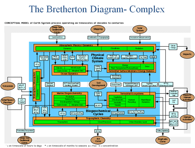
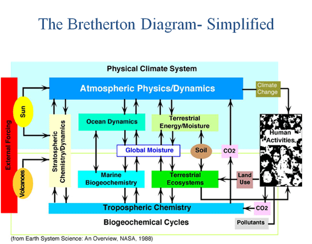
Return
to JSC Oral History Website
|